Thursday 31 / July / 2025
New Delhi: The US space administration NASA and the Indian Space Research Organisation (ISRO) together launched an Earth-mapping satellite on Wednesday. The NASA-ISRO Synthetic Aperture Radar (NISAR) satellite is designed to track even the tiniest of changes in the Earth’s surface.
The goal of the $1.3 billion (€1.14 billion) mission is to help understand what leads to both manmade and natural disasters, such as floods, landslides and volcanic eruptions.
NISAR launched at 12:10 GMT from the Satish Dhawan Space Centre on the southeastern coast of India.
"Congratulations India!" India's minister of science and technology, Jitendra Singh, posted on X once the satellite safely reached orbit.
What is NISAR’s mission?
Now in orbit around Earth’s poles, NISAR has got a busy 3 years ahead of itself. While 747 kilometers (464 miles) high, observing melting glaciers and polar ice sheets are among the satellite's research goals. NISAR will measure the Earth's surface twice every 12 days, observing shifts as small as 1 centimeter (0.4 inches).
The satellite won't be able to predict the next earthquake but "it will help us better understand which areas of the world are most susceptible to significant earthquakes," the mission's geoscience lead, Mark Simons, said in a statement on NASA's website.
"We'll see land substance and swelling, movement, deformation and melting of mountain glaciers and ice sheets covering both Greenland and Antarctica, and, of course, we'll see wildfires," added Karen St Germain, director of NASA's Earth Science division.
She called NISAR "the most sophisticated radar we've ever built."
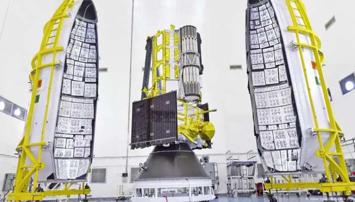
How does the 'first of its kind' satellite work?
NISAR is the world's first radar imaging satellite to use two radar frequencies. The so-called L-band radar is provided by NASA, and the S-band radar was developed by ISRO. These radars operate around the clock to capture Earth in extreme detail and can reportedly capture measurements regardless of weather conditions.
The two radars will beam signals down to Earth. When these signals bounce back, the satellite will receive them via its huge antenna reflector. Scientists will then compare the incoming and outgoing signals as the satellite passes over the same location.
"The potential applications from the satellite are huge, and the global scientific community is eagerly awaiting the satellite data," ISRO Chairman V. Narayanan said after the launch.
"It is not going to be used by one or two countries. The entire globe is going to benefit from this great accomplishment," he said.
NASA Deputy Associate Administrator Casey Swails said the satellite "really shows the world what our two nations can do."
The launch marks the biggest space collaboration between the United States and India. NASA contributed $1.2 billion for the low-frequency radar and reflector, while ISRO contributed $91 million for the higher-frequency radar and main satellite structure.
India’s space program has seen a boost in recent years. In 2014, it placed a probe in Mars orbit and, in 2023, it landed a rover on the Moon.
Shubhanshu Shukla recently became the first Indian to reach the International Space Station.